Recently, whilst trying to find a footpath across the marshes between Higham & the Thames, I came across an old causeway that has an interesting history. My interest was aroused initially by the causeway's proximity to feature on the map named 'Barrow Hill' which may have been a Bronze Age burial mound. Detailed information was difficult to find but I gradually pieced together its history.
This area has always been well populated since at least Neolithic times. There are several reasons for this. The marshes & the nearby Thames estuary provided a plentiful source of food such as wildfowl & fish. Also the area consisted of much rich meadowland before sea levels rose & the area was partially inundated during the Middle Ages.
The river & estuary provided easy access both inland & overseas allowing contact with peoples in other parts of Britain, continental Europe & beyond. This is proven by several significant archaeological finds made in the vicinity.
These include pre-Roman Gallo-Belgic coins found concealed in a hollow flint not far from the causeway & a large amount of Phoenician pottery discovered in the estuary at Egypt Bay which is situated a little further downstream. ( 'Egypt Bay' gets its name from this find). Roman pottery has been found on numerous occasions, pieces often being unearthed when new graves are dug in St. Mary's churchyard and a large amount was discovered during repair work on the seawall in the 1950's. Records suggest that during their successful invasion of Britain in 43 AD it was across this causeway on Higham marshes that the Roman army pursued a significant proportion of the Ancient Briton's forces before they fled across the Thames to Essex.

The causeway winds its way across the marshes.
 A Dyke borders the causeway for much of its way.
Barrow Hill lies ~100 metres east of the causeway. It was always assumed to have been a Bronze Age burial mound but excavations during the late 19thC. discovered little of significance & now some believe that it may be simply a mound on which a bonfire could be lit to guide the ferry over from Essex during bad weather.

Lesser water parsnip growing in the Dyke alongside the causeway.
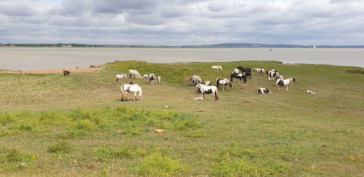
Semi-wild ponies & their foals graze by the saltmarsh where the causeway meets the Thames. This crossing to East Tilbury in Essex is believed to have been a ford originally & the Romans extended the causeway right across the river here. However, rising sea levels during the Middle Ages made both of these impassable & a ferry was put in their place. This remained in operation until the 16thC. when the service was transferred upriver to Gravesend.
St. Mary's church lies on the edge of the marshes close to the beginning of the causeway. A church was founded here in 774 during Saxon times but the current church was rebuilt after the Norman Conquest & then remodelled & enlarged during the 14thC. when a priory of Benedictine nuns was established nearby. The priory was responsible for maintaining both the ferry & the causeway & was allowed to levy a fee for this. It closed in 1522 & nothing of it remains except for remnants of a wall on land at a neighbouring farm. Interestingly, St. Mary's was Charles Dickens' local parish Church & his daughter, Kate, was married here. The church is now redundant & under the care of the Churches Conservation Trust.
The 15thC. door of St. Mary's church is finely carved with motifs of roses, lilies & human faces.


All this information about Higham is readily available in A History of Higham, Vols I & II, published in 2011/12 - plus lots more on the village besides. Might be worth checking in there if you need more details. Available from the library or post office.
ReplyDeleteThank you for that information Arthur. I will definitely check it out. That area is fascinating in so many ways.
Delete